Betchworth & Buckland Nature Trail
Geology & Soils
A Walk Through Worlds Long Past
Understanding the geology of the landscape adds a new dimension to our understanding of the nature that the landscape supports. Another way of viewing the Betchworth and Buckland Nature Trail is to see it as a walk through more than 100 million years of geological history.
Figure 1 provides an extract from the geological map for the area with the nature trail superimposed as a white line. Walking the trail from St Michaels Church in Betchworth to the North Downs we are effectively moving from older to younger periods of geological history (h2 and h5 Figure 1) – with the complication that overlying these older rocks there are much younger sediments deposited at the end of the last ice age (T Figure 1) or more recently by the River Mole (A Figure 1).
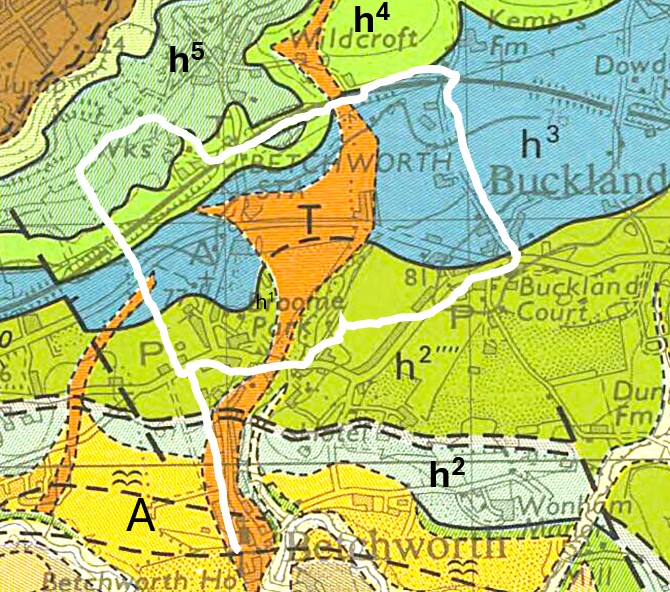
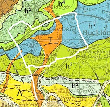
Figure 1 Geological map with nature trail (white line) superimposed.
Geological history of the area
The oldest rocks visible in the wider landscape are the Wealden clays, laid down in shallow freshwater lakes and river deltas about 130 million years ago, when southern England lay at a similar latitude to present-day North Africa. These rocks outcrop south of the R. Mole and do not influence the nature trail.
Above these sit the Lower Greensand beds (h2 on the map) formed about 125 million years ago. These are fine-grained sands and silts deposited as a warm, shallow sea began to inundate the Weald — and it is this greensand, free-draining and slightly acidic, that underlies the Common Field south of Betchworth post office - a recent site of sand extraction but now restored. They are the same sands that were extracted from the quarry that now contains Buckland Park Lake and they are an important an important aquifer for our drinking water.
The trail then crosses the Gault Clay (h3 on the map), a band of dense, dark, impermeable marine clay running east to west laid down in deeper, quieter seas around 110 to 100 million years ago. These rocks occupy the poorly drained fields that border the A25 in Betchworth and also the fields adjacent to Rectory Lane in Buckland.
Above the Gault lies the Upper Greensand (h4 on the map) formed about 100 million years ago. It comprises a narrower band of firmer, more calcareous sandstone that forms a subtle step in the landscape before the ground rises sharply to the chalk of the North Downs escarpment. The deep railway cutting east of Betchworth Station cuts through Upper Greensand.
The Chalk (h5 on the map) lies above the Upper Greensand. It was formed between 100-66 million years ago from the compressed remains of billions of microscopic marine organisms accumulating on a tropical sea floor over millions of years. The white cliffs above Betchworth, are the remnants of chalk quarrying.
After the sea retreated, and during the same mountain building period in which the Alps were formed around 35-30 million years ago, the sedimentary strata described above were gently folded into the great Wealden anticline, then eroded over geological time to expose the sequence of rocks visible today as the layered landscape of Weald, Greensand ridge, and Chalk escarpment.
The River Mole and its tributaries completed the shaping of the valley floor during the ice ages, cutting through the softer clays and sands and leaving the low-lying, seasonally waterlogged ground that the nature trail now crosses.
Soils, Vegetation and Farming
Each of the different strata described above generates its own soil, and each soil shapes what grows — and what farmers and wildlife can do with the land. The Greensand produces light, sandy, acidic soils that drain freely and warm quickly in spring; historically these were used for market gardening and orchards, and they support heathy vegetation, with plants tolerant of low nutrient levels.
The Gault Clay is very different: heavy, water-retentive, slow to warm and prone to waterlogging in winter, it creates the wet pastures and damp field margins that are among the most wildlife-rich habitats in the valley. Several fragments of ancient woodlands also grow in these clays. Where the Gault lies close to the surface, springs emerge along its upper edge — the classic spring line of the chalk escarpment foot — feeding the ditches and wet flushes that sustain sedges, rushes, and the invertebrates that depend on standing water.
The chalk soils of the escarpment above support a contrasting flora of fine-leaved grasses, orchids and chalkland wildflowers, grazed by sheep for centuries and now managed as some of Surrey's most valued downland.
Farming has always followed geology here and shaped the landscape: the Greensand farms grew fruit and vegetables, the clay pastures carried dairy cattle and sheep, and grew Ash and Hazel for construction, while the chalk downland supported sheep — a pattern of land use shaped not by choice alone, but by the rocks beneath. As farming practices changed, for example the decline of grazing in the North Downs, so the landscape changed as the downland was invaded by scrub and woodland.